Automatically predicted deforestation. (Animation: David Dao)
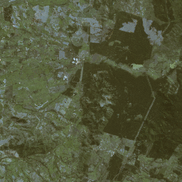
As Dao explains, the algorithms read sequences in order to recognise which areas are forested and whether these areas are shrinking. These sequences are individual images strung together in chronological succession – much like old film reels or comic strips. So when a new road is built through the rainforest, for instance, numerous smaller roads form off it over time. It is along these roads that the forest coverage is destroyed.
From a bird’s-eye view, the resulting pattern resembles the skeleton of a fish, with its spine and small bones – thus the moniker “fish bones”. By comparing these chronologically sequential aerial views, algorithms can determine how road systems and forest coverage change over time.
This means that intelligent algorithms don’t need labels to generate an overall image indicating where rainforests are shrinking. They can also predict where the worst deforestation will appear next. This model also applies to deforestation near rivers and around agricultural areas.
Test run in the Chilean rainforest
For the research project, which is called Komorebi, David Dao has attracted partners from the field, including Chile’s forestry authority CONAF (Corporación Nacional Forestal). In January, a pilot project will start in the Valdivian rainforest, on the Pacific coast south of the capital, Santiago. Dao will be testing and tweaking his predictive algorithms in real rainforest conditions. His approach may be able to detect not just overall decline in the rainforest, but also determine which species of trees are most affected.
This is a significant factor in climate change, as different types of trees store CO
2
at different rates, and one approach to forest conservation is to offer local populations financial incentives for retaining trees as CO
2
storage rather than clearing the forest.